How to Request a Mouza Map Using Plot Number (2026 Updated Guide)
The process of obtaining a Mouza map in West Bengal has become fully digital through the Banglarbhumi land records system. Instead of visiting government offices or relying on paper-based records, users can now access detailed cadastral maps online using plot-specific search options.
To proceed, users need to open the Mouza Map section on the portal and select the required district, block, and Mouza information. After that, entering the correct plot number linked to the land allows the system to fetch official survey records and display the corresponding land map instantly.
This modern digital approach has significantly improved land record accessibility, making it easier for individuals to verify ownership details, support legal documentation, and assist in property-related decisions with improved speed, transparency, and accuracy.
How to Request a Mouza Map with Plot Number
Open the Official Portal
Start by visiting the Banglarbhumi land records portal. Use your registered login credentials to access the citizen dashboard where all land-related services are available in one place.
Go to Citizen Services Menu
From the main dashboard, open the “Citizen Services” section. Look for the option labeled “Mouza Map Request” and click to proceed with the map search process.
Verify Map Records
Before continuing, check whether LR (Land Record) and RS (Revisional Settlement) maps are available for your selected Mouza. This ensures accurate and updated land data.
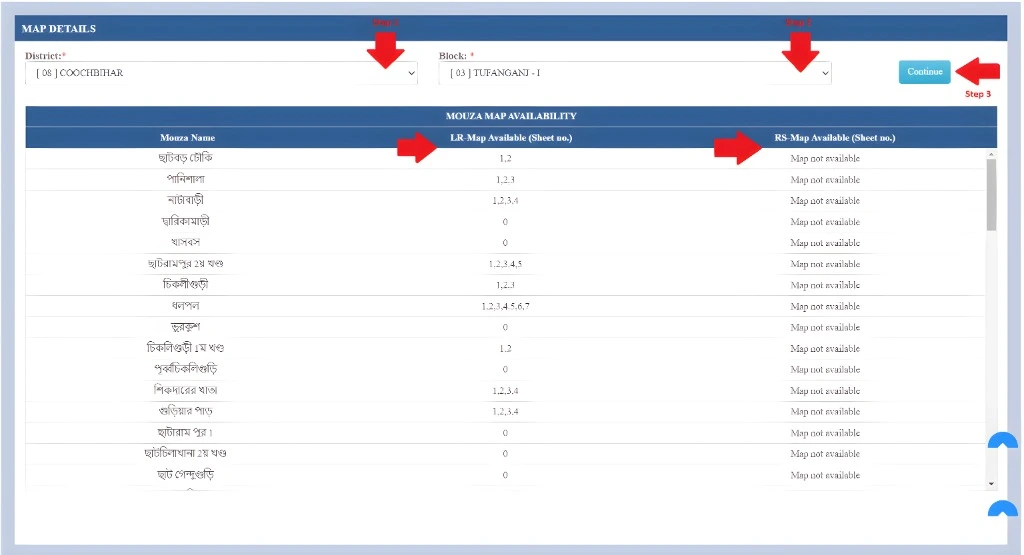
Select Location Details
Choose your district, block, and Mouza carefully. After that, enter the sheet number and select the map type (LR or RS) according to your requirement.
Locate Your Plot
Click on the “View Mouza Map” option and search for your specific plot number on the digital map interface to identify the exact land location.
Fill Applicant Information
Enter your personal details including name, guardian’s name, and full address. Complete the captcha verification to confirm your request submission.
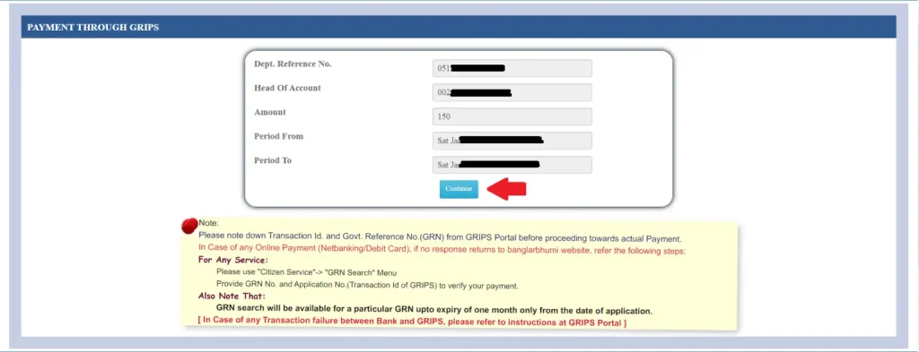
Complete Payment Process
Pay the required service fee of ₹150 through the available online payment options. Once payment is successful, your request will be processed automatically.
Download Your Map
After successful submission, you will receive an Application Number and GRN. Use these details to download your official Mouza Map anytime from the portal.
Important Details (2026 Updated Information)
Application Fee: The service charge for obtaining a Mouza Map is ₹150.
Map Options: Users can request either LR (Land Record) Maps or RS (Revisional Settlement) Maps based on the required record type.
2026 Enhancement: The latest digital system now supports app-based and online access, allowing users to request maps more conveniently using plot-specific details. This upgrade has significantly improved processing speed and data accuracy in land-related services.
This improved framework also helps reduce fraudulent activities and ensures greater transparency for landowners, property developers, and government officials handling land records.
How to Check Mouza Map Availability Online
To verify whether a Mouza map is available for a specific location, you can easily use the Banglarbhumi portal. The system allows users to quickly check map records without visiting any government office.
Step-by-Step Process
First, log in to the official Banglarbhumi portal using your registered credentials. Once you reach the dashboard, navigate to the Citizen Services section where all land-related services are listed.
From there, select the option labeled “Mouza Map Availability Details”. This feature is designed to help users confirm whether digital or recorded maps exist for their selected area.
Next, choose your required District and Block from the dropdown menus. Make sure the information is accurate, as availability depends on the exact administrative location.
After selecting the details, click on Continue to proceed. The system will then process your request and display all available Mouza map records related to that region.
You will be able to view whether maps are available and what type of records exist for the selected area.
Map Types Explained
The Mouza map system provides different types of land records to help users understand both current and historical land information. Each map type serves a specific purpose in land verification and documentation.
LR (Land Record) Map reflects the most updated and revised land details based on recent surveys and land reforms. It shows current ownership patterns, plot boundaries, and the latest administrative updates, making it the primary reference for modern land transactions.
RS (Revisional Settlement) Map is based on older survey records, typically from the 1960s settlement data. It is mainly used for historical comparison and verifying changes in land structure over time.
Together, these map types help ensure accurate land assessment, legal clarity, and better understanding of property evolution.
What is a Mouza and Why It Matters?
A Mouza is a basic revenue land unit used in official land records, typically consisting of a group of plots identified by unique plot numbers. It serves as an administrative boundary for maintaining land ownership and survey records in a structured way.
Mouza plays a crucial role in land management and documentation because it forms the foundation of all land-related records used by the government and landowners.
Why Mouza is Important
- Legal Ownership Records: It helps maintain official proof of land ownership and ensures that every plot is properly recorded under government revenue systems.
- Inheritance & Transfer: Mouza records make it easier to handle property inheritance, sale, and transfer processes in a legally recognized manner.
- Dispute Resolution: Accurate Mouza mapping assists in resolving land disputes by providing clear boundary and ownership details.
- Government Data Management: It ensures that land information remains updated and systematically organized for planning, taxation, and development purposes.
What is the Mouza App?
The Mouza App is a digital platform designed to provide quick and easy access to land records, plot information, and ownership details through official government databases. It allows users to view updated land data without the need for manual paperwork or visiting revenue offices.
By using this app, landowners and citizens can search plot numbers, check property details, and verify ownership information in real time. It improves transparency, reduces delays, and makes land-related services more accessible and efficient.
Overall, the Mouza App simplifies land record management by bringing essential services directly to users through a digital interface.
Key Features of the Mouza App
The Mouza App is designed to make land record access simple, fast, and transparent by offering a range of useful digital features for users.
- Plot-wise Land Record Access: Users can search and view detailed land information by entering specific plot numbers for accurate results.
- Mouza Boundary Maps: The app provides clear digital maps showing Mouza boundaries, helping users understand land divisions and locations easily.
- Ownership Details: It displays registered ownership information, making it easier to verify property rights and legal status.
- Historical Land Records: Users can also access older land data to compare past and present records for better clarity.
- Updated Land Registration Information: The app keeps land registration data up to date, ensuring users always get the latest verified information from official sources.
Overall, these features make the Mouza App a reliable tool for managing and verifying land-related details efficiently.
Why Request a Mouza Map with Plot Number?
Ownership Verification
A Mouza map helps confirm the legal owner of a plot before any land transaction. It allows buyers and sellers to verify whether the property is correctly registered in government records, reducing the chances of fraud or misinformation during purchase.
Detect Legal Disputes
Checking a Mouza map using a plot number helps identify if the land is involved in any disputes, litigation, or boundary conflicts. This ensures that the buyer or user is fully aware of any legal issues before making financial or legal commitments.
Required for Loans & Documentation
Banks and financial institutions often require verified land maps during loan approval and documentation processes. A Mouza map serves as an official proof of land details, helping speed up loan processing and legal verification.
Accurate Construction Planning
Before starting construction, it is essential to confirm exact land boundaries and plot details. A Mouza map ensures accurate site planning, preventing encroachment issues and ensuring development within legal boundaries.
Application Modes: Online vs Offline
Mouza map applications can be submitted through two official methods depending on user convenience, digital access, and regional system availability. Both online and offline modes are legally valid, but they differ in process flow, speed, and user experience.
Online Mode (Digital Application Process)
The online mode is the most advanced and widely used method in states where land records have been fully digitized. States such as Maharashtra, Telangana, Karnataka, and West Bengal have implemented dedicated government portals to handle land-related services digitally.
In this system, users can apply directly from their mobile phone or computer without visiting any office. The process begins by accessing the official land records portal and logging in using registered credentials. After login, users navigate to the Mouza map service section and fill in required details such as district, block, Mouza name, sheet number, and plot number.
Once the form is completed, applicants are required to verify the entered information carefully before submission. The system then redirects users to an online payment gateway where the application fee can be paid securely.
After successful payment, the application is processed electronically, and users can track the status in real time. Once approved, the Mouza map can be downloaded directly from the portal using the application reference number.
This method is preferred because it offers faster processing, reduced paperwork, transparent tracking, and instant digital access to land records.
Offline Mode (Traditional Office-Based Process)
The offline mode is used in areas where digital infrastructure is limited or where users prefer manual submission. This process requires physical presence at government offices such as the Tehsil Office, BLRO (Block Land & Land Reforms Office), or Income Circle Office.
To begin, the applicant must visit the concerned office and collect the Mouza map application form from the designated counter. The form must be filled carefully with all necessary land details including plot number, Mouza name, and applicant information.
After filling out the form, the applicant submits it along with the required fee at the office counter. In some cases, supporting documents such as identity proof or land records may also be requested for verification purposes.
Once the application is accepted, the office issues an acknowledgment slip or receipt, which serves as proof of submission. The processing time may vary depending on the workload and local administrative procedures.
Although slower than the online method, the offline process is still important for rural areas and ensures accessibility for users who are not comfortable with digital systems.
Common Online Application Steps
Required Documents
Cost of Application
Key Points
Verify Plot Number Carefully
Always double-check the plot number before submitting your application. Even a small mistake can lead to incorrect map results or rejection of your Mouza map request.
Choose Certified Copy for Legal Use
For legal matters, property disputes, or bank loans, always select a certified Mouza map copy. It is officially verified and accepted as valid government documentation.
Combine Multiple Plots if Required
If your land consists of more than one adjacent plot, make sure to combine them correctly during the application process for an accurate and complete land representation.
Enable Browser Pop-ups
Ensure that pop-ups are enabled in your browser settings. Many map downloads, payment pages, or verification screens require pop-ups to function properly.
Keep Application Number Safe
After submitting your request, save the application number carefully. It is required to track your status, download the map, and resolve any future issues.
Check Details Before Final Submission
Before final submission, review all entered details such as district, block, Mouza, and plot information to avoid errors and ensure smooth processing.
Common Issues and Solutions
Plot Not Found Issue
Sometimes the system may not display your plot number during search. This usually happens due to incorrect entry or outdated records. In such cases, cross-check your Khatian (Record of Rights) details and ensure the plot number and Mouza information are entered correctly.
Portal Loading or Error Issues
If the Banglarbhumi portal shows errors or fails to load properly, it may be due to browser compatibility or server load. Try clearing your cache, switching to another browser, or accessing the site during non-peak hours for smoother performance.
Ownership Mismatch Problem
In some cases, ownership details may not match current records due to recent property transfer or inheritance. To resolve this, you need to apply for mutation so that government records are updated with the correct ownership information.
Application Processing Delay
Delays in Mouza map processing can occur due to high application volume or verification requirements. If your request is taking longer than expected, it is recommended to contact the local revenue office or BLRO office for status updates.
How to Fix Missing Plot Numbers on Mouza Map
Missing plot numbers on a Mouza map usually occur due to incomplete digitization, outdated records, or selection errors during the search process. To resolve this, first verify your ROR (Record of Rights) or Khatian details, as these documents confirm whether the plot exists in official land records. Next, carefully check that you have selected the correct Mouza, block, and district, since even a small mismatch can cause the plot to disappear from the map view. If the plot still does not appear, you should submit a correction request through the official land record portal. In cases where online correction is not possible, visiting the local land revenue office is necessary for manual verification and record updating.
Correcting Wrong Plot Numbers
Wrong plot numbers typically arise due to clerical errors, outdated data, or mismatch between physical land documents and online records. To fix this, compare your registered sale deed with the information shown on the portal to identify inconsistencies. If discrepancies are found, you must submit a formal correction request along with valid supporting documents. In cases where ownership has changed due to sale, inheritance, or transfer, applying for mutation becomes necessary to update government records. Proper documentation such as deed copies, identity proof, and land records must be attached for successful correction.
Historical Mouza Map Changes
Historical Mouza maps such as LR (Land Record) and RS (Revisional Settlement) maps play an important role in understanding how land boundaries have changed over time. These older maps reflect earlier survey conditions and ownership structures. However, modern digital land record portals primarily display updated and current data only. Therefore, historical maps are mostly used for comparison, research, or dispute analysis rather than official land transactions.
Plot Number vs Dag No vs Khatian
Understanding land records requires knowing the difference between key terms. A Plot Number or Dag Number identifies the exact physical location of a piece of land within a Mouza. The Khatian number represents the ownership record and contains details of the landowner and associated plots. The Mouza refers to the overall administrative land boundary that contains multiple plots. Together, these three elements form the complete structure of land identification and ownership tracking in official records.
Boundary Dispute Resolution
Boundary disputes occur when there is confusion regarding land limits between neighboring plots. To resolve such issues, the first step is to verify the official survey map for accurate boundary details. If further clarification is required, a Field Measurement Book (FMB) can be requested, which provides detailed measurement records of land parcels. When disputes remain unresolved, the local revenue office may conduct a re-survey to determine and officially mark correct boundaries.
Without Plot Number Search
If a plot number is not available, users can still search for land information using alternative details such as Mouza name, block, and district. Once the map is generated, the land can be identified visually by analyzing nearby landmarks and plot boundaries. This method is especially useful when users have incomplete land details or old documents without clear plot references.
Legal Validity of Mouza Map
A Mouza map is an important supporting document in land-related matters but does not serve as standalone proof of ownership. It becomes legally valid when combined with Khatian records and registered sale deeds. Together, these documents provide complete legal evidence for ownership verification, property transactions, and dispute resolution cases. Courts and revenue authorities generally consider all three documents collectively for legal validation.
Symbols on Mouza Map
Mouza maps use different symbols to represent land features and boundaries. These include plot boundaries, roads, water bodies, internal divisions, and survey markers. Each symbol helps users understand land layout clearly and identify exact property locations. Proper interpretation of these symbols is essential for accurate land analysis and planning.
Tracking Application Errors
Application errors during Mouza map requests can occur due to technical issues or incorrect input data. Users should first track their application using the application ID provided after submission. If the issue persists, clearing browser cache or switching to a different browser may resolve the problem. In case of continued errors, contacting the official helpdesk or local revenue office is recommended for technical support and correction.
High Resolution Map Download
High-resolution Mouza maps can be obtained by requesting a certified copy through the official portal. Some systems also provide GIS-based map viewing options for detailed digital analysis. If digital download is not available or sufficient, users can visit the local land revenue office to obtain printed copies. These high-quality maps are often used for legal, construction, and survey purposes.
Video Guide
FAQs – Mouza Map (Plot Number Guide 2026)
Frequently Asked Questions About Mouza Map Requests, Plot Search, and Online Land Records System
What is a Mouza Map?
A Mouza Map is an official land record map that shows plot boundaries, ownership details, and land divisions within a specific Mouza for legal and administrative purposes.
How can I request a Mouza Map using a plot number?
You can request it through the Banglarbhumi portal by selecting Citizen Services → Mouza Map Request, entering district, block, Mouza, and plot number, then completing payment.
What is the fee for obtaining a Mouza Map?
The standard application fee is ₹150, which may vary depending on map type, certification, and government updates.
What is the difference between LR and RS maps?
LR (Land Record) maps show updated and current land records, while RS (Revisional Settlement) maps are older survey records used for historical comparison.
Can I download the Mouza Map online?
Yes, after successful application and payment, you can download the Mouza Map using your application number or GRN from the official portal.
Why is my plot number not showing on the map?
This may happen due to incorrect Mouza selection, outdated records, or missing digitization. Verify Khatian details or contact the local land office for correction.
Is Mouza Map legally valid?
Yes, but it is usually used as a supporting document along with Khatian and sale deed for complete legal ownership verification.
What should I do if my application fails?
Check your internet connection, verify entered details, clear browser cache, or retry using another browser. You can also contact the revenue office for help.
Can I apply without a plot number?
Yes, you can search using Mouza, block, and district details and then identify the plot visually on the map interface.
How do I track my Mouza Map application?
You can track it using your application ID or GRN number on the Banglarbhumi portal under the application status section.
Final Thought
The Mouza map request system through the Banglarbhumi portal has made land record access much simpler and faster in 2026. Users can now easily apply online using basic details like district, block, Mouza, and plot number. This digital process reduces the need for physical office visits and manual paperwork. It also improves transparency and accuracy in land-related information. Overall, it is a more efficient and reliable way to manage and verify land records.